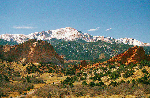
Another warm weekend in Colorado led to another hike snuck into the month of March. This time, a group of us headed towards Pike's Peak National Forest, to explore a hike out of Green Mt Falls, CO. The area around Colorado Springs has been warm this time of year, and the weather sure didn't disappoint during this hike.
Beautiful blue skies hung overhead as we set out along the steep dirt road toward Catamount Trail. The road met the trailhead high along the ridge, but there was still a good bit of work to go before reaching the ridge. Along the way, pockets of shade harbored treacherous ice along the trail. We had a nice walk, but quit before reaching the reservoirs and views of Pike's Peak at the top. A new burger joint was calling our name.
This area is amazing, considering its proximity to Colorado Springs. It would make a wonderful hike on a hot summer day, the trail being so shaded and the reservoirs along the ridge. It was great for wetting my appetite - Now I can't wait to climb Pike's Peak.
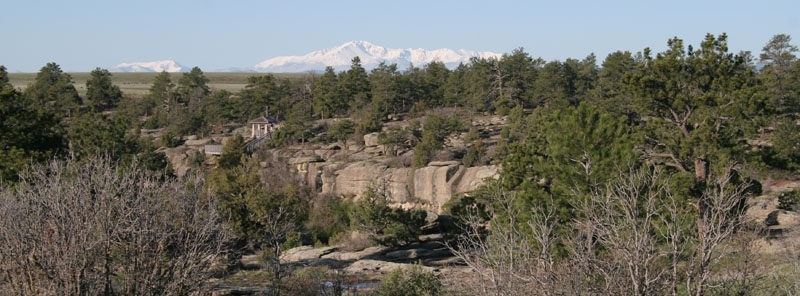
After a few weeks of some variable weather that included a foot of snow or two, the Front Range was bestowed with some splendid, sunny weather. Zoe, a couple of friends and I took advantage of the warm rays and headed down to Castle Rock. We headed down to Castlewood Canyon State Park, a day-use park within the Colorado State Park system. With day-use as a priority, the park has no campsites, but boasts around 50 picnicking sites.
While certainly not a backcountry destination, Castlewood Canyon is perfect for several tryps of activities including trail running, birdwatching, picnicking, and rock-climbing. The park's vicinity to Denver and Colorado Springs is perfect for groups of climbers looking to socialize.
This ecological region is particularily unique because it sits right between the mountains of the Front Range and the plains grasslands of Eastern Colorado. Those zones meet here, along the Palmer Divide, a peninsula that divides the drainage basins of the Arkansas and Missouri Rivers.
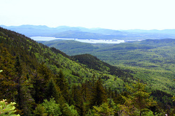 Moosehead. What can you really say about Maine's biggest lake? Its big, its out there, and three of us took off for it this weekend. First up, after an enticing evening at Lily Bay State Park, was Big Moose. Formerly known as Big Squaw, Big Moose Mountain rises just over 2,000 feet above Moosehead Lake. And, as it turns out, a lot can be said about Moosehead Lake. It is New England's largest lake, sprawling over 100 square miles and containing 80 some-odd lakes, and its waters flow directly into the Kennebec River, a flow that eventually empties into the Gulf of Maine at Merrymeeting Bay. The most distinguishing characteristic of the lake is certainly remoteness. From Big Moose Mountain views extend across the western portion of the lake where hardly any development is visible. In fact, the extended views from the top of the mountain led to a fire tower being built in 1904.
A Sunday forecast of rain influenced us to reverse our itinerary. We decided to head up Big Moose early Saturday morning, in order to summit with clear views. We headed out from Lily Bay, already swatting at insects before even getting to the trailhead. The trail is easy enough to find, just take 15 through Greenville about five miles out of town, keeping an eye out for the sign directing you left onto a dirt road. Not too far in, the trailhead is on the right.
The trail up Big Moose is about three miles. The first couple miles rise nicely through stands of birch trees. Ground sorrel follows the path up the entire way. Being mid-June we saw quite a few nice wildflowers amid moose poop scattered in piles every few steps. Warblers sang off in the distance, and a rich, humus-y smell permeated the air.
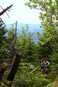
Somewhere around the two-mile mark the views begin to open up. These overlooks are certainly a welcome sight, but they come with a price. The trail begins a steep(ish) ascent not too long after they appear along the trail. Some stone steps begin to filll the trail and not too long after heading up some wooden stairs the old warden's cabin appears on the right.
The entire thing looks and feels as if it could fall down at any moment. Enter at your own risk. We did stop and check it out, but only for a moment before moving on. Walking ahead, discussions arose among the three of us where we pondered being up here, alone, especially when the weather was bad. It most certainly takes a certain kind of person to enjoy that lifestyle, and I am sure that my fellow hikers were, like I was, silently questioning if they had that lifestyle in them.
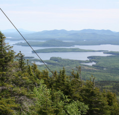
The fire tower at the top of Big Moose provides a great opportunity to take a break and picnic. The warblers, at this point, are singing far below. Views of Kathadin, Camden Hills, and even the western mountains are visible on a clear day like the one we were lucky enough to enjoy. The ultimate goal among my group was camping on Little Moose Pond, so we headed out the way we came, so that we could begin our hike onto the lower ridge via the Greenwood Trail. This is most certainly not the only way to get to Little Moose from its larger neighbor. It takes only about a mile or so of hiking in once you are back to the trailhead. We wanted to keep walking though, and had been eyeing the ridge that Greenwood Trail took up to the chain of ponds all week, so down we headed.
This is a fun trail with some great payoff, but ultimately it isn't an ultimate destination. I would highly recommend adding this walk onto a series of walks in the immediate area, with plans to camp at one of the ponds along Little Moose Mountain. Chances are, you will have the place to yourself. Well, you and some moose, some loons, a bunch of warblers, ducks, chipmunks, beavers and quite a few other non-humans.
On Saturday, Chelsey, Zoe and I headed towards Gorham, New Hampshire. Our goal was the Mahoosuc Range. We set out for the mountains with our snowshoes, not really sure what the conditions would be like. Temperatures were already in the 40's on the coast, and the forecast called for rain showers. The skies were grey the entire drive west, toward the mountains. Cruising through exotic locals like Paris and Poland, we began to wonder just what kind of walk we were in for. Chelsey and I began to discuss clothing options, checking with each other to see what kind of waterproof gear we had brought between us.
Crossing the Androscoggin a couple of times, and entering some beautiful country, the sky began to clear. As we set out, snowshoes strapped to our feet, we even spotted a patch or two of blue sky. At that point it wasn't raining either, and our spirits were high. It looked like we would be catching a break on this dark and stormy, late-winter New England day.
The snow underfoot was pretty wet, but we slogged on slapping the ice formations that collected constantly to the bottom of our crampons. This was a constant annoyance on the way up, but never made for a difficult walk. Zoe loved the conditions, sticking mostly to the easier path carved by our snowshoes along the trail. We were walking along the Appalachian Trail, just outside of the Presidential Range. The Presidential Range is a series of mountaintops named after past presidents, and it wasn't until we returned from our trip that I learned that Mt. Hayes does NOT refer to Rutherford B. It instead is named for Mrs. Margaret Hayes, first owner of the Gorham hotel.
Mt. Hayes overlooks the town of Gorham, NH and from the top wonderful views of the Presidential Range. It made for a great three to four hour winter hike. Through beautiful birch stands and deep, dark Canadian hemlock forests. We only saw one other person, a cross-country skier and her two golden retrievers. Yet even at the top, this section of the Whites feels anything but remote. Dogs can be heard among the cruising snowmobiles, and the incessant drone of a generator went on the entire trip, though we hardly noticed this during the actual walk. We probably won't approach the Mahoosuc from the Centennial Trail, or Mt. Hayes in the future. More remote angles are difficult to access in the winter, due to road closures. IN the summer, we will probably come in from the north, maybe passing Gorham on the way toward Crawford Notch.
|